
How to use these Maps
Simply hover over a map, and you will see a magnification of part of the map to the right in which you can pan around.
Alternatively you can view the whole maps as large jpg files by clicking on the title, and clicking on the enlarged map will further enlarge. Please remember that these maps are Copyright; but permission is granted for their download and use for Educational and Research purposes.
Please note the map images are large files and depending on your bandwidth can take anywhere from a few seconds to a minute to load.
Map I

Development of Oxford to the Early 13th Century
This map shows the area of early 8th century settlement around St Frideswide’s and the Anglo-Saxon town-soon-city that grew up to the north of it. The orange lines indicate the extent of the Saxon wooden palisade walls, with the city centre at the crossroads at Carfax, and the city gates. The coming of the Normans brought in the extensions of the city walls in stone to incorporate the Norman Castle and two suburbs to the east. The Jewish quarter and its cemetery are shown in yellow. Royal properties—key to the exceptional security of the Jews in Oxford (who, like all Jews, were wards of the Crown) are indicated in purple. Individual properties indicated in red were the so-called Mural Mansions at a certain point in time (1222)—houses of the most prominent Christian townspeople who held the responsibility for the upkeep of the city walls—and indicate that the new urban elite had more or less abandoned the oldest city area around St. Frideswide’s.
Map I + Overlay

Overlay: Orientation with Modern Oxford
Map II
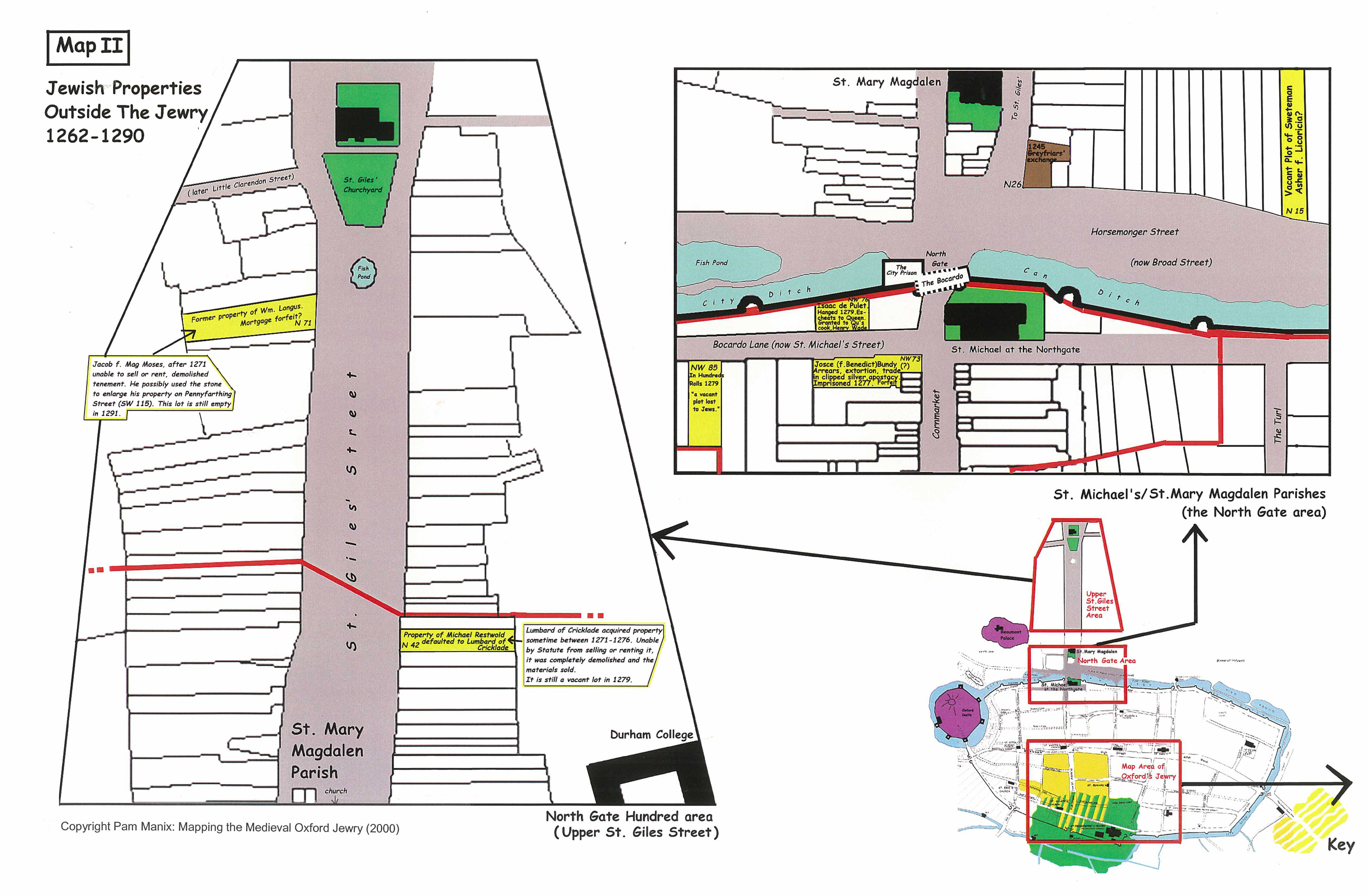
Jewish Properties Outside the Jewry
1262 – 1290
The Oxford Jewry was not a ghetto situation (which developed 300+ years later) but simply existed as a “Jewry” because most Jewish families preferred to live in the same area. Jews and Christians lived cheek-by-jowl in the Jewry, and by all accounts enjoyed all the usual relations, with Christian neighbours coming to light lamps and fires on Shabbat and Jews being neighbourly in return. There was an infamous marriage between a Christian deacon and a Jewess in the 1220s which ended in the execution of the man for converting to Judaism.
Jews owned properties outside the Jewry in Oxford often as the result of mortgagees defaulting on loans, which the Jew would then sell or, before 1281, rent out for income. The properties indicated in St. Giles were of this type.
But not all Jews chose to live in the Jewry. The area immediately around St. Michael-in-the-Northgate was a bit of a low-rent district due to the city prison, the Bocardo, being attached to the city walls of the Northgate. Isaac de Pulet’s family lived next to the prison, and the notorious Jewish ne’r do well, Josce Bundy lived across the street.
Map III
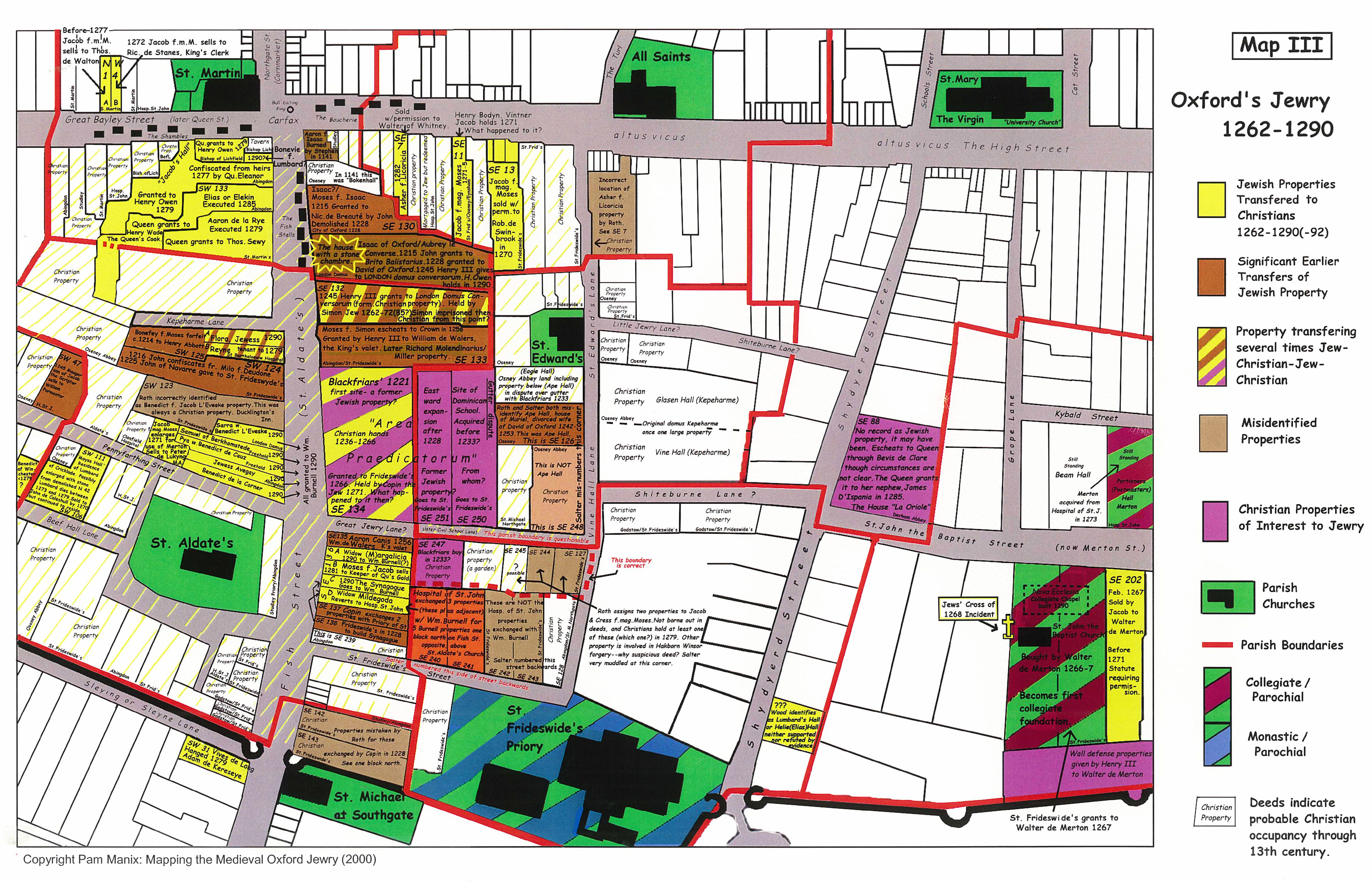
The Oxford Jewry 1262-1290
(with many earlier Jewish properties indicated)
Great Jewry was centred along what is now St, Aldate’s and the side streets, many of which were obliterated when Christ Church was being built. Little Jewry Lane and St. Frideswide Street connected Great Jewry with Vine Hall lane to the east, and Pennyfarthing Lane (now Pembroke Street) contained many Jewish houses, along with Kepeharm Lane, which is now a private taxi lane, and Beef Hall Lane which has since been absorbed into Pembroke College. Earlier Jewish stone-built houses were also located east of Great Jewry—Merton College and Oriel were both founded in Jewish properties, and others were located throughout what is now Christ Church. Blue Boar Street did not exist until centuries after the medieval Jewish period.
Map IIIa
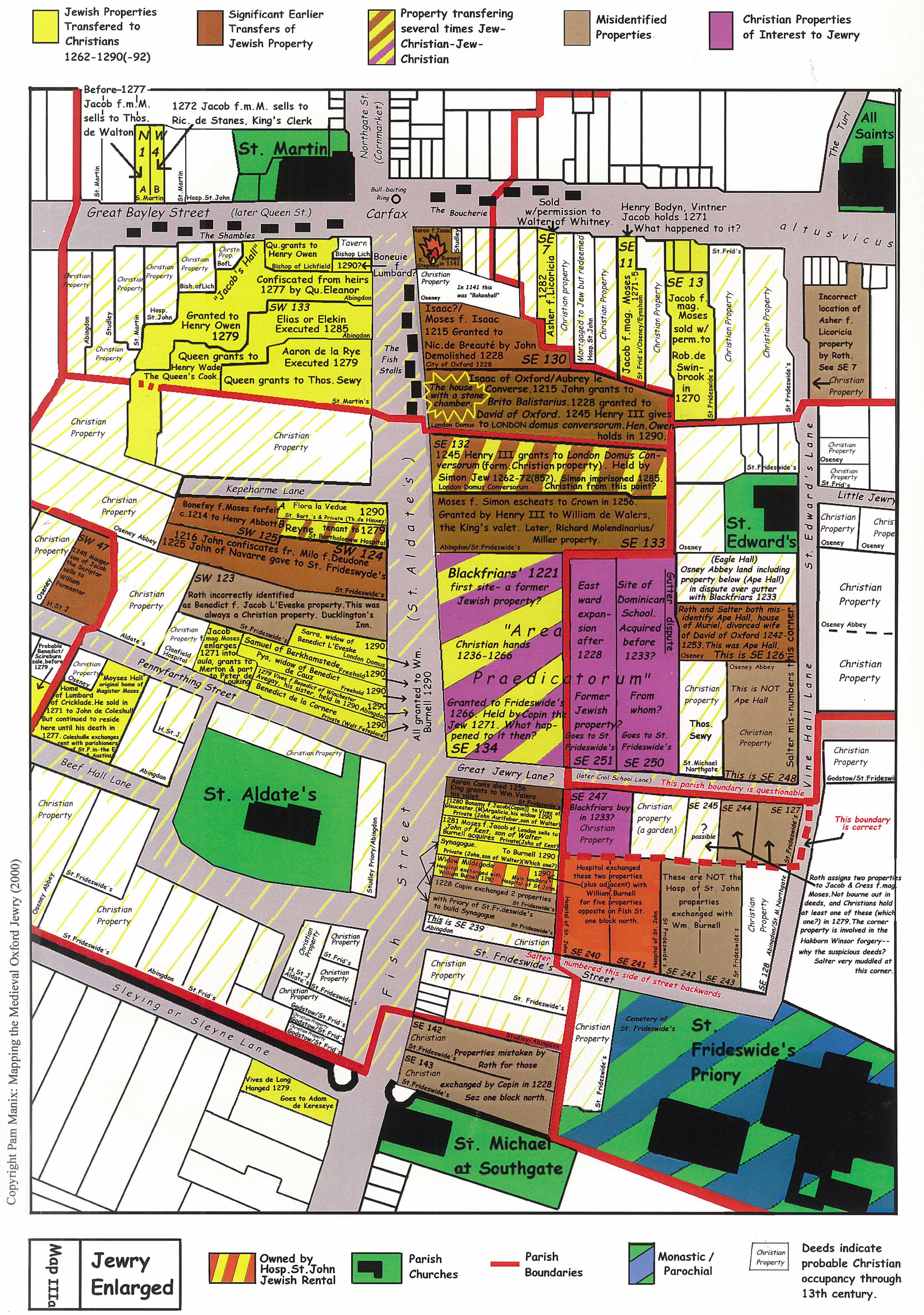
The Jewry Enlarged
Jewish stone-built houses ran down both sides of St. Aldate’s, in decreasing size, it seems as the approached the South Gate. One stone house further distinguished in the deeds as The House with the Stone Chamber, was one of several Jewish houses located where the present Town Hall sits. The King actually gave a vacant Jewish house to the town in 1228 to use as a town hall when they outgrew the Guild Hall on Queen Street. The Synagogue was established in that same year opposite Pennyfarthing Lane. Two large Jewish properties located near the top of the west side of Great Jewry have curious boundaries, as if each bought up pieces of neighbouring properties in a somewhat random pattern. It is possible these two properties, suitably located on the gravel level above the River Thames, were trying to gain access to the water table below the gravel in order to feed an underground mikveh. Despite the plethora of details we know about the medieval Oxford Jewry, the community ritual bath has never been located. These properties were not only in an ideal position within the community and situated on the gravel, but a later pub in the area named Jacob’s Well could well attest to the mikveh having been located there.
Map IV
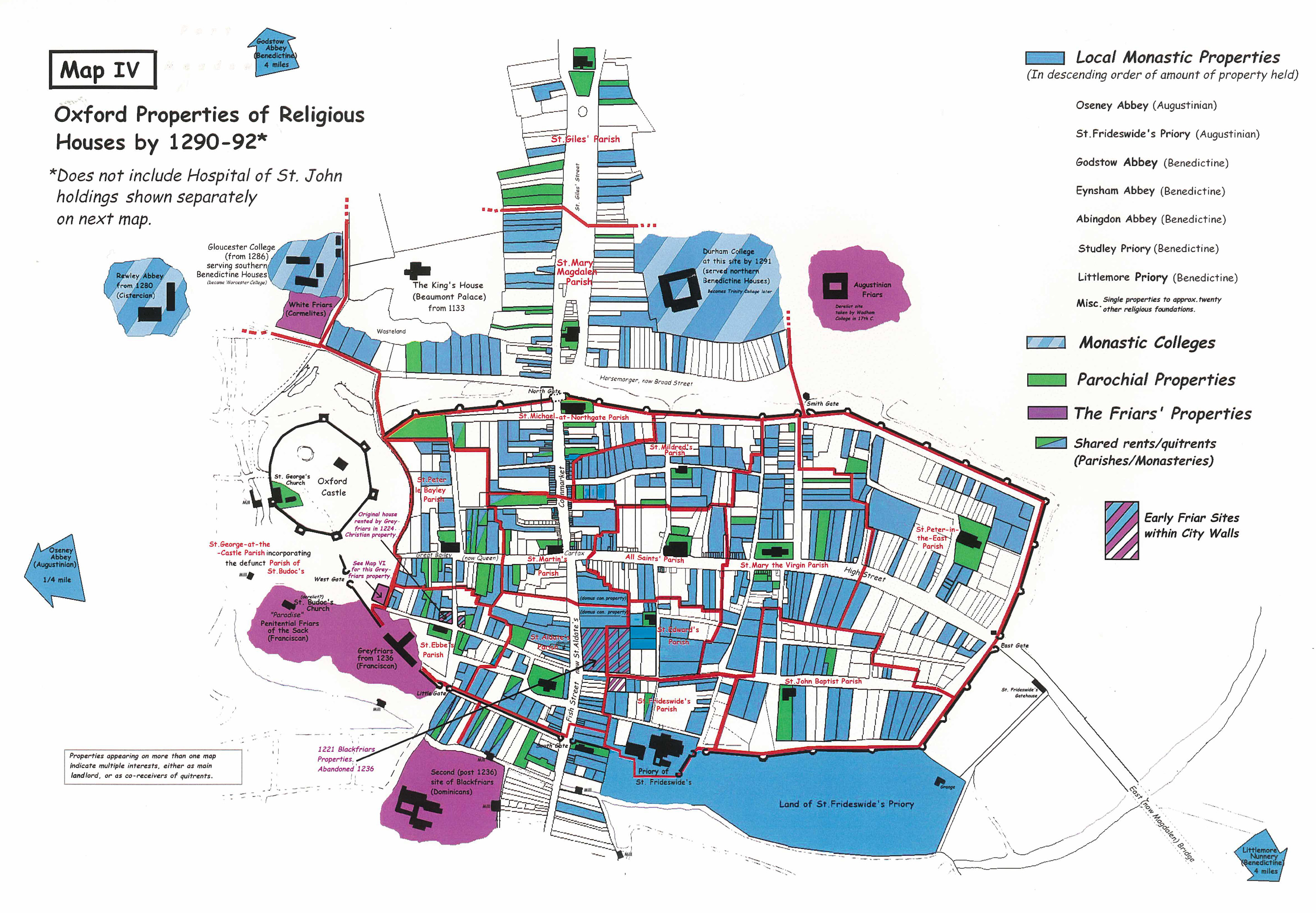
By 1290 – 92
Oxford Properties of Religious Houses
Map IV shows the properties within Oxford owned by the monasteries and friaries, which increased even further in the 13th century as England-wide foundations sent scholars to study at the nascent university. In addition, by 1200, the urban middle classes started leaving annual ground-rents on their individual properties to religious establishments in hopes of availing their families of religious indulgences in perpetuity. Within two decades virtually every Oxford property had been quit-rent deeded to various local religious houses. Map IV indicates property deeded to local favourites Osney Abbey, St. Frideswide’s Priory and Godstow Abbey, as well as the abbeys at Eynsham and Abingdon and numerous other local foundations such as Studley and Littlemore Priories.
Map V
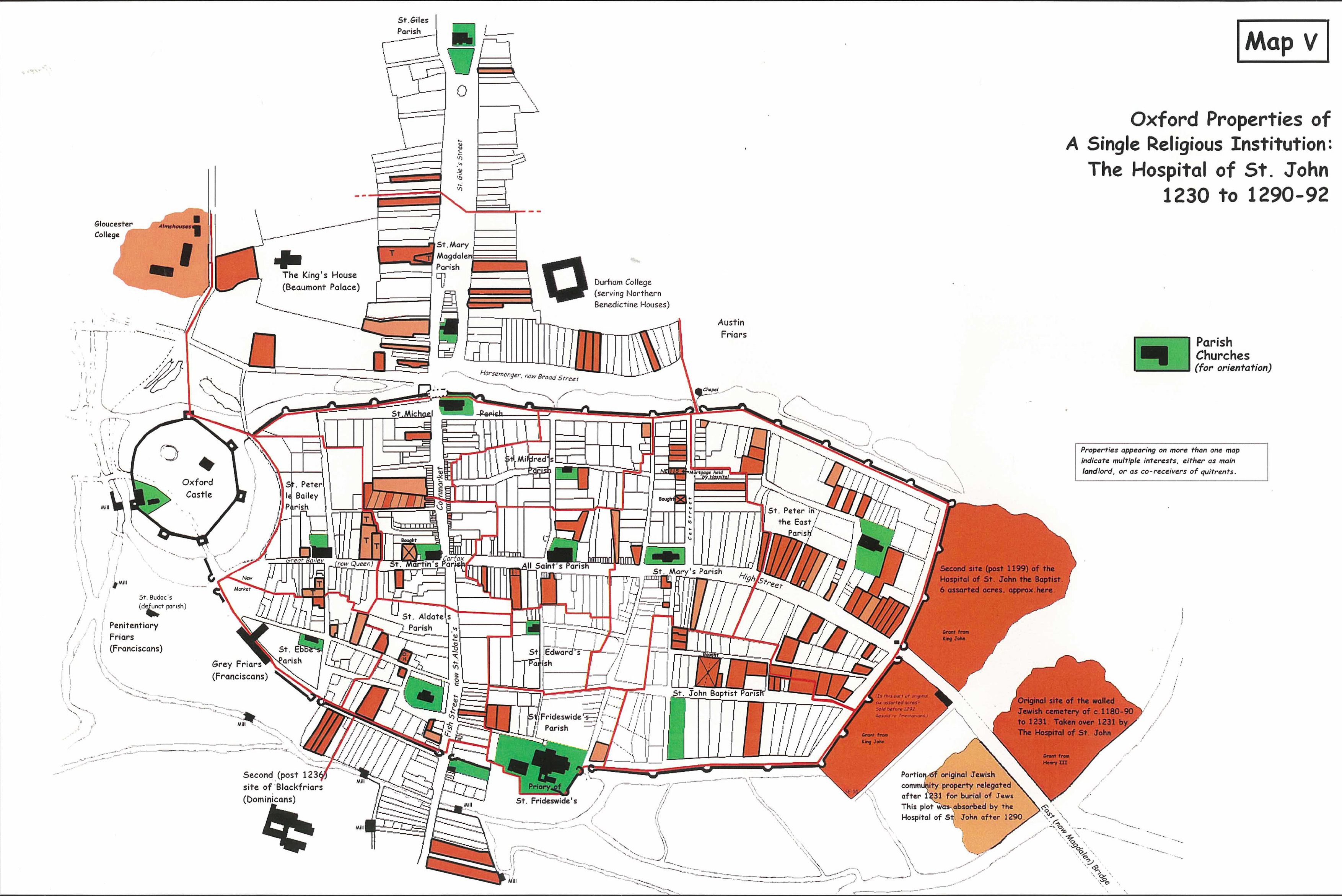
Oxford Properties of A Single Religious Institution:
The Hospital of St. John
1230 to 1290-92
Map V, for the sake of illustrating the influence of a single foundation, maps the properties associated with the Hospital of St. John alone (which later was absorbed by Magdalen College) so that you can see the properties on Map IV and V together represent almost complete coverage of all properties within the city of Oxford. This is key because the 13th century deeds of all the properties of all these ecclesiastic foundations ended up in the hands of the various Oxford Colleges that superceded them, both before and particularly following the Dissolution of the Monasteries. It is these records which have allowed us to map the 13th century Jewish quarter in Oxford so well.
Map VI
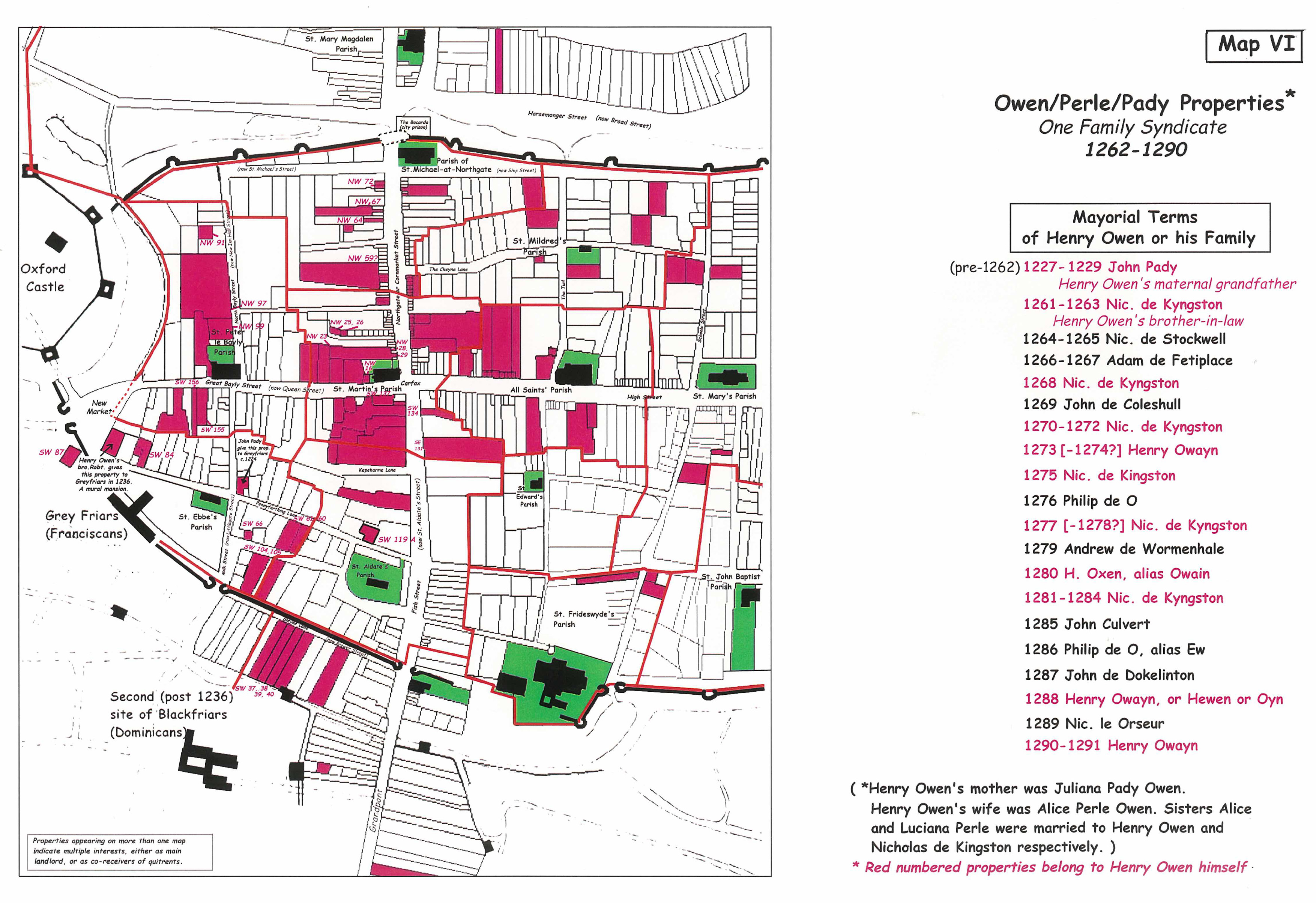
Owen/Perle/Pady Properties: ?One Family Syndicate? 1262 – 1290
Edward I’s queen, Eleanor of Castile, was notorious for using insider information on Jewish transactions to enrich the Queen’s Treasury and extend influence to court insiders. In 1275, Eleanor somewhat arbitrarily confiscated the estate of Jacob of Oxford and was taken to court by Jacob’s widow and heirs. They lost. The Queen’s winning lawyer was Anthony Bek, who had been an old lodger of Jacob’s when Bek was at Oxford. After dispossessing Jacob’s family, Eleanor gave the property to Henry Owen, a member of a very prominent Oxford family. The Queen’s dealing in Jewish bonds and real estate had made her extremely unpopular in London and other centres—it is not known whether this gift was to curry favour with an influential Oxford family in hope of offsetting some of her unpopularity.
Map VII
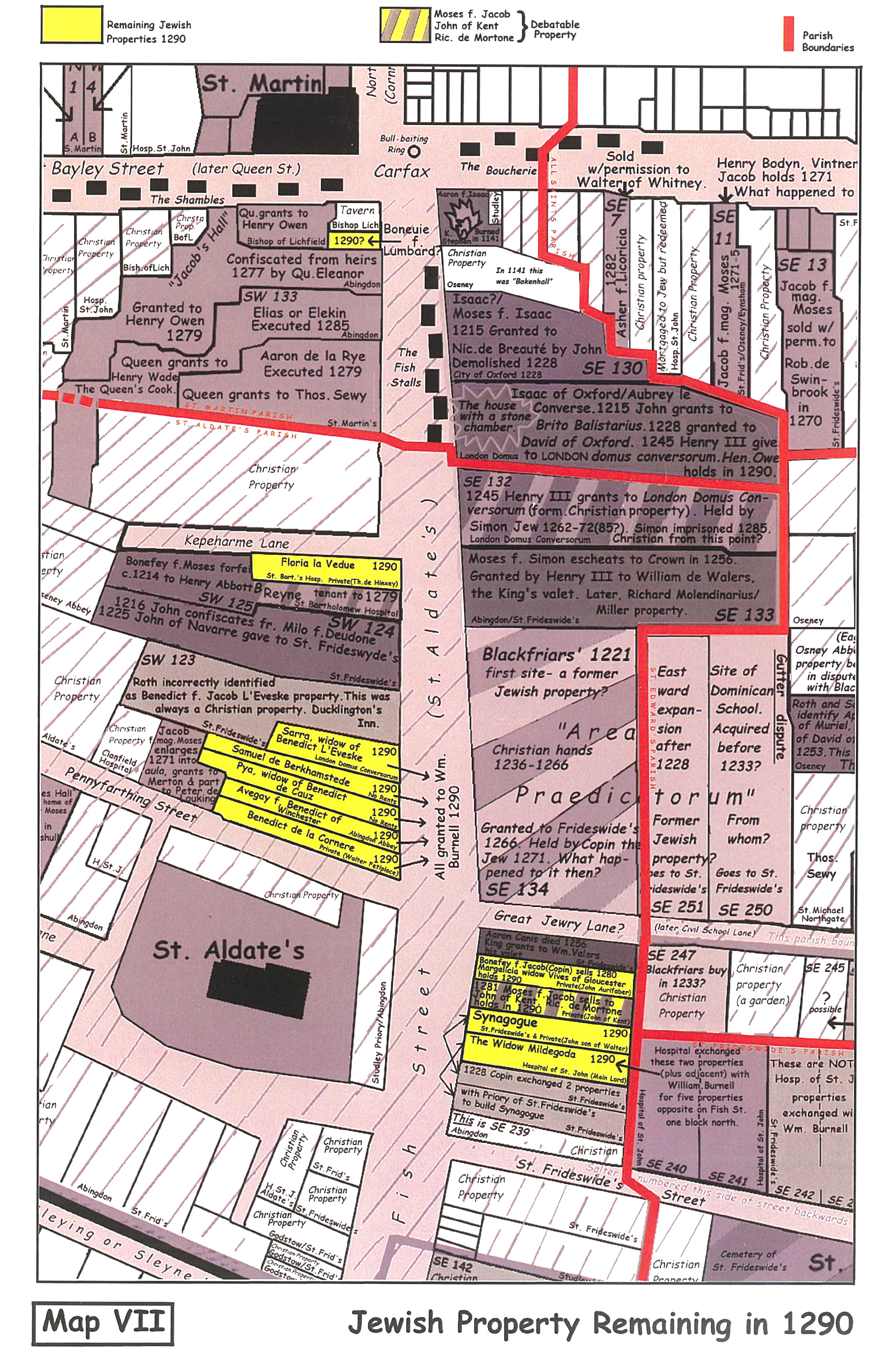

Jewish Property Remaining in 1290
In 1290 only the 9 properties in yellow remained in Jewish hands—the community had been impoverished and shrunken after nearly 2 decades of progressively tighter restrictions imposed by Edward I, in response to demands by the increasingly indebted parliamentary classes. In the autumn of 1290, after a final bargain with Parliament for funds to support his expensive wars in Scotland, Wales and France, Edward gave all English Jews 3 months to leave the realm, taking with them only what they could carry. Most Jews returned to Northern France from whence England’s Jews had originally come, and where many still had family and other ties.
Map VIII
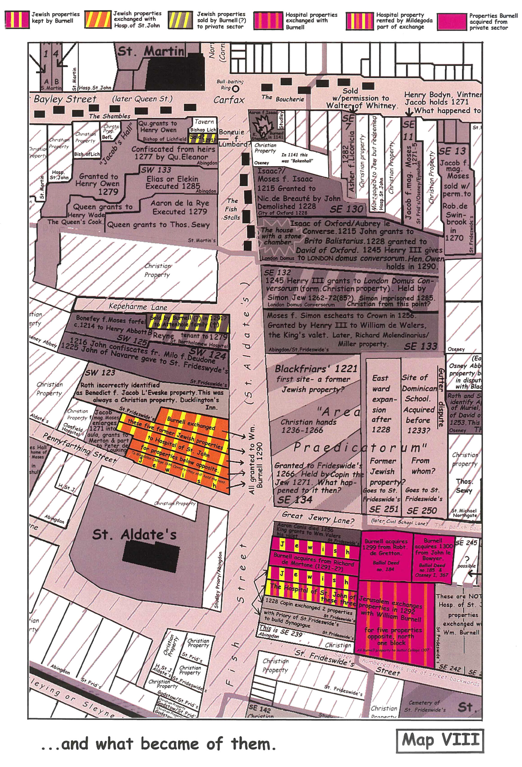
…and what became of them.
All Jewish property and uncollected debts in 1290 became property of the King. The nine Oxford Jewish properties were acquired by William Burnell, the archdeacon of Wells Cathedral, who was, perhaps more importantly, the brother of the Lord Chancellor, Bishop Robert Burnell. William Burnell sought to consolidate the Jewish property into one sizable site by selling off some properties, and buying other properties adjacent to the largest group of conjoined Jewish holdings including the Synagogue. He traded the five small Jewish properties on the west side of Great Jewry with the Hospital of St. John who owned two larger properties bordering these Jewish properties on the east side. Magdalen College, who took over the properties of the dissolved Hospital of St. John in the 1540s, still has the deeds of these five 13th century Jewish properties.
Was William Burnell acting for his brother, the Chancellor, who may have wished to establish a residential college in the manner of Walter de Merton, the previous Chancellor? It does not seem likely that William Burnell, a somewhat minor cleric, would have had such ambitions in his own name, a theory which is somewhat born out in subsequent events. A college establishment never got off the ground and, with his brother dying rather inconveniently in 1292, William spent the rest of his life unsuccessfully trying to consolidate the Oxford Jewish properties into something advantageous. When he died in 1302 William left the still-undeveloped college site consisting of 6 properties, 4 of them formerly Jewish, to his old college, Balliol. Although Christ Church now incorporates the Burnell site, Balliol still has the four 13th century Jewish deeds that came with Burnell’s bequest.